Aussie drones on bushfire alert
Advanced drone and satellite technology to deliver early warning systems for wildfires.

As Australia braces for the summer bushfire season, drone and satellite technologies are tooling up to play a critical role in firefighting efforts.
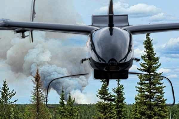
With a spike in summer temperatures escalating the threat of wildfires worldwide, a drone developed by Sydney-based Carbonix has already been helping to battle wildfires in Canada, where flames scorched an area twice the size of Portugal.
Its Volanti drone conducted large-scale aerial surveys across rugged, remote terrain to help spot old 'zombie fires' smouldering in tree roots beneath the ice with the potential to suddenly reignite.
Carbonix says the Volanti is one of just a handful of drones able to fly the vast distances required for executing aerial surveys. Equipped with a variety of payload sensors, for Beyond Visual Line of Sight (BVLoS) operations, it has undergone rigorous testing from ANU-Optus Bushfire Research Centre and the ACT Rural Fire Service.
"Australia contains huge areas of bushland, and fires often break out in multiple remote areas simultaneously."
In Canada the drone was flown by specialist Quebec-based operator Exo Drone and supported by US-based fire monitoring specialist ArgenTech Solutions over the peak Canadian bushfire season.
It has also proved to be particularly effective in detecting fires sparked by lightning strikes - a common scenario in Australia according to Carbonix CEO Philip van der Burg.
“Australia contains huge areas of bushland, and fires often break out in multiple remote areas simultaneously,” van der Burg said.
“The aim is for these fires to be spotted in their infancy and contained before they become mega blazes.”
And as a cheaper and safer alternative to crewed aircraft or ground teams, Carbonix says the Volanti drones can also be used to assess the fuel load to help fire crews plan hazard reduction burns to reduce the risk for the coming fire season.
Protecting National Parks
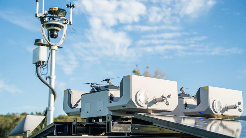
Another company preparing for the upcoming Australian bushfire season is Sphere Drones, which recently signed a contract with NSW National Parks and Wildlife Service (NPWS).
Its HubX drone systems will be used in the NSW Government’s Natural Hazards Technology Program and CEO Paris Cockinos said they will be safeguarding some of the most ecologically important regions in New South Wales.
The HubX system is an integrated, off-grid solution mounted on a 4WD trailer. With BVLoS capabilities it can be operated in rugged, isolated areas and will initially be deployed across national parks including Kosciuszko and Yathong.
"HubX’s innovative technology will allow NPWS to deploy drones quickly in remote areas, boosting their capability to monitor high-risk zones, prevent bushfires, and conserve endangered wildlife,” Cockinos said.
Eyes in the sky
Tech giant Google has also joined the firefighting effort, teaming up with satellite maker Muon Space to develop a purpose-built constellation of satellites called FireSat tasked with detecting and tracking wildfires as small as a classroom (roughly 5x5 metres).
"Until now, firefighters have had to rely on satellite imagery that’s either low resolution or only updated a few times a day, making it difficult to detect fires until they’ve grown larger than a soccer field," Google says.
"With FireSat, authorities will have high-resolution imagery that is updated globally every 20 minutes, helping them respond to fires before they become destructive."
Using AI, FireSat will rapidly compare any 5x5 meter spot on Earth with previous imagery and Muon Space plans to launch a single satellite next year followed by the launch of three satellites in 2026.
To kickstart the project, Google provided US$13 million in funding to the initiative led by the Earth Fire Alliance, a nonprofit established to launch the FireSat constellation.